SKILL LEVEL
extreme
Our team is here to support you 24/7. Please feel free to provide your queries. You will get response within few minutes.
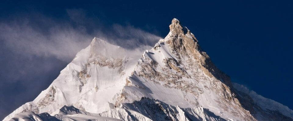

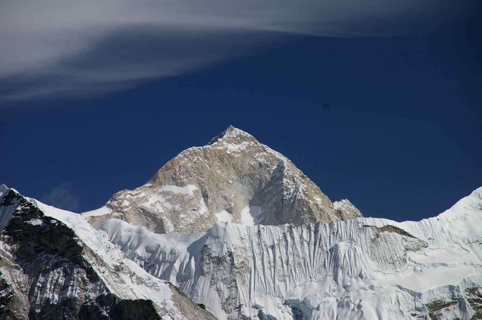
Manaslu is the world’s eighth-highest peak at an altitude of 8,163 meters (26,781 ft). Located in central-western Nepal, it is part of the Mansiri Himal range of the Himalaya. The Sanskrit word manasa means “intellect” or “soul,” hence the name Manaslu translates to “mountain of the spirit”. It is located at about 64 kilometers east of Annapurna. The mountain’s extensive ridges and valley glaciers allow for approaches from many angles, leading to a top that stands dramatically above the surrounding terrain.
After being initially scaled by a Japanese expedition by Toshio Imanishi and Gyalzen Norbu in 1956, the peak has subsequently gained popularity among mountaineers. Extremely steep slopes, erratic weather, and challenging terrain make Manaslu famous for both its magnificent scenery and its challenging climbing conditions. The people also attach spiritual and cultural importance on the mountain, seeing it as a representation of their history and identity. Join us for a once in a lifetime adventure on Manaslu.

46 Days Expedition / (SKILL LEVEL: extreme)
Day 01: Arrival in Kathmandu (1300m/4,265ft)
Day 02: Preparation day for legal formalities, team briefing and rest (1300m/4,265ft)
Day 03: Heli Flight to Samagaun (3,541 m/11,617 ft)
Day 04: Rest at Samagaun (3,541 m/11,617 ft)
Day 05: Trek from Sama Gaun to Manaslu Base Camp (4700 m/ 15,420 ft)
Day 06: Preparation for Puja Ceremony and rest at Base Camp
Day 07: Puja Ceremony, gear and equipment preparation for rotation.
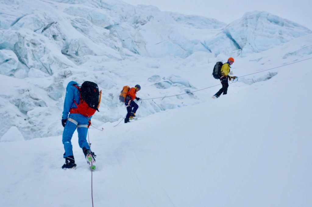
Day 08: Climb to Camp I, Over night at Camp I (5500 m/18,045 ft)
Day 09: Rotation to Camp II and return back to Camp I Day 10: Climb to Camp II, Overnight at Camp II (6200 m/20,341 ft)
Day 11: Rest and Acclimatization at Camp II
Day 12: Rotation to Camp III (6800 m/22,310 ft) and return to Camp II
Day 13: Descend to Base Camp from Camp II
Day 14 – 18: Rest Days
Day 19: Climb to Camp I (5500 m/18,045 ft)
Day 20: Climb to Camp II (6200 m/20,341 ft)
Day 21: Climb to Camp III (6800 m/22,310 ft)
Day 22: Climb to Camp IV (7400 m/24,278 ft)
Day 23: Summit Day (8163 m/26,781 ft) and return to Camp II or Base Camp
Day 24: Rest Day at Base Camp
Day 25: Direct Heli Flight from Base Camp to Kathmandu (1300m/4,265ft)
Day 26: Extra Day at Kathmandu for gear pack up and farewell dinner
Day 27: Final Departure
On arrival at Tribhuvan International Airport meet our staff with EHM complimentary transport transfer to relevant Hotels, our guide will give you briefing of the Hotel, Kathmandu, Trekking, and related information that you might require while in Nepal with Expedition High Mountain.
In Kathmandu for necessary government paper works and permits and preparation for the expeditions
Early breakfast, then travel by Coach to Gorkha and unto Arughat on the Kathmandu-Pokhara scenic highway. This is an interesting drive through the foothills of the Himalaya. The road has been greatly improved in recent years. An interesting 5 hours drive from Kathmandu, the drive passes through many rural villages and town, with occasional view of the peaks of Langtang, Ganesh, Manaslu and as far to Annapurna. Our route diverts from the Pokhara highway from the village of Abu Khaireni, from here the road climbs all the way to our destination at Gorkha and then to Arughat town-village for the overnight stop.
From here onwards the walk follows the Buri-Gandaki river upstream, the trail from Arughat are much narrow passing through more rural farm villages and terraced fields with numerous streams to cross in between, the path follows the right bank of Burhi Gandaki, passing through cultivated land, with many scattered farmhouses and hamlets reaching the village of Mordar, Simre and then to Arket. This low trail, which sometimes takes to the river bed, is not possible during the monsoon season. After climbing briefly to Kyoropani, then descending once again to the river for the at the confluence with the tributary Soti Khola the ride leads to Machha Khola for the overnight stop outside the village, which has a number of teashops.
The trail from here leads to more interesting farm villages and fields as the vegetation changes slowly, beginning the morning walk crossing the stream that gives its name Machha Khola (Fish stream) and heading upstream to the tiny village of Kholabensi and the hot springs at Tatopani. From here the valley sides becomes steeper, until the path becomes impassable the route then switches to the left bank of the river by way of suspension bridge, after a short section of forest path coming to some teahouses at Doban, then walking to reach at Lauri crossing the River on a suspension bridge from here leading to a climb on a high path, descending into open valley at place known as Yara Khola. Journey continues for another hour to the village of Jagat. Jagat is quite a big village after Arughat; the people around here are of mixed race Magar, Chettris, Brahman, Bhotias (Tibetan looking tribes) and some few Newars merchant and shopkeepers.
The trail from Jagat descends to a long series of stone steps to the river, from here the path climbs a terraced hillside to Saguleri, overlooking distance view of Sringi Himal 7,187m from this spot, the walk follows ups and down trail as we reach to the bridge over Buri-Gandaki, after crossing the bridge from Ghata-khola, the path winds up towards Philim village. From here the trails climbs slowly along the hillside passing through small settlements of Aga, Lokwa. After Lokwa it’s a downhill to camp at a small place Nyak or at Eklaibhati near Shiar khola with great views looking over the valley towards Pangsing.
An hour walk crossing to the east side of the river. The path follows up and down in some section the trail is cut into the sheer cliff walls, after this dramatic portion the track finally improves as the walk leads to Deng village, the houses and terrains completely changes into more Tibetan like from here onwards. The people here are of Tibetan origin along with their ancient culture. Villagers of this areas cultivates buck wheat, wheat, barley and potatoes as staple crops, beside this since trekking became popular around this area, spinach, carrots and cabbages are also grown. After 3-4 hours of walk brings you at Bih, our journey continues for another two hours on this steep sided and impressive valley, coming across mani prayer stone and finally at Ghap village for the overnight camp which straddles the river across a short wooden bridge. There is a strong Tibetan influence at this village.
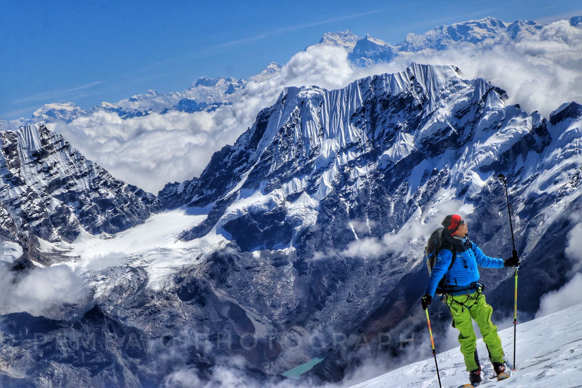
From here onwards the trekking is pleasantly cool as the walk begins to gain height and enter the alpine forest. The walk continues steeper up as the valley opens out with quite extensive pastures with more steady climb then crossing a large stream flowing down from the Lidana Glacier, with magnificent view of the snow peaks on the north Kutang Himal range with Pang Phuchin 6,335m, and Saula Himal 6,235m and other unnamed peaks of over 6000m. On the southern lies the Manaslu Himal and Simang Himal range with its array of over 7000m peaks. The walk is pleasant; with gradual uphill the altitude gains slowly as the walk pass through farm villages of Sho-Namru, Beng-sam till the village of Sho is reached. The people from here onwards are engaged in farming during the summer, the young folks in winter travels to trade in big cities Nepal, and India. Just above the village of Sho, scenery of Manaslu north and then of Manaslu 8,163m ahead, an hour walk brings to Lho for the overnight camp, Lho, a large village with a lovely little monastery and numerous chortens and Mani walls. Ganesh I is visible, on looking back.
On leaving the Lho village, trek continues following the river on the right bank, with view of Peak 29 ahead, Two hours of climbing through the forest leads to the village of Shala which offers excellent view of Phungi, Manaslu and Himal Chuli. A couple of hours further leads us to Samagaon village, with superb view of Mt.Manaslu. Samagaon, one of the biggest village of this region, the people are mostly farmers growing what they could in this harsh terrains and cold climate, like buck wheat, barley are the main crops, potatoes and few varieties of vegetables grow in this soil. The people like their ancestors descended from Tibet as early as 300 years back, the culture and their living style is very much like they predecessor. The people of this area still trade with Tibet taking 2 or 3 days to week. The border to Tibet is a day walk for the locals. It is one of the old salt trade route from Nepal to Tibet.
From here is just half hour walk up to our camp at Sama gompa just above the village of Samagaon. On reaching the camp near Sama-Gompa, we will have time to visit the Monastery one of the major Nyligpa (red hat sect) Monastery of this region.
Today a rest day, free from packing; a day hike is worthwhile can be done towards Manaslu glacier or near to its base camp.
After an easy day at Sama Gompa, today’s trek climbs slowly towards the Base Camp the trails meanders on the winding track towards south and beyond. Actually the walk to Base Camp is not too far can be done within 3-4 hours but due to the increase in altitude and the dry air makes the walk a little slower than previous days, need to gain the height slowly taking time and enjoying the view around as you come to the large meadow at the foot of the towering Mt.Manaslu to establish the Base Camp.
Necessary day for acclimatizing and preparations for the long big climb to the summit of Mt.Manaslu.
From the campsite crossing a high plateau and then skirt around the ridge of lateral moraine heading towards the mountain as the climb progress after 3-4 hours of good walk and climb finding a suitable camp site for the Advance Camp.
We have allowed 21 days Expeditions period to prepare fully with the all the arrangement for the upper camps ferry of the loads to and fro and for the final ascent to the summit on the clear fine morning.
After an adventurous and challenging week return back to Base Camp.
All the Expeditions should be here by now to pack and ferry the load to the road head and to clean the base camp as it was before.
Retrace the journey back to Arughat on the downhill path and reaching to the warm-tropical area.
After all the packing and reloading the gear in the Truck and Bus return journey is made through the new route Dhading as it is more accessible and shorter reaching Kathmandu on time.
Two days in Kathmandu, this day will allow you for the last hour to shop around and to prepare the Expeditions report to be submitted to the respective Government Department and for a guided tour around at places of interest.
Today as per your international flight time, keep your confirmed air ticket, our Staff will take you to the airport for your final departure atleast 3 hrs before.
Arrival & departure transfer from and to the airport & hotels.
Accommodation in Hyatt Regency in Kathmandu (bed and breakfast).
Teahouse accommodation on full board (breakfasts, lunches & dinners) during the trek.
Base Camp accommodation in a individual box tent with a comfortable mattress.
Base Camp Service (shared with the group) includes a kitchen tent with the cook, kitchen boy, dining tent with tables and chairs, shower tent, toilet tent, storage tent, gas heater, etc.
High altitude food and Epi gas burner for the members and staff for their stay at high camps.
5 oxygen bottles, mask, and regulator for members; 1 bottle from Camp II to Camp III, 1 bottle to move to Camp IV, and 3 bottles for Summit Push at 4 Litre (Extra mask and Regulator in case needed). 2 bottle each for climbing Sherpa and Guide.
Heli Flights: Kathmandu – Sama Gaun & Basecamp – Kathmandu for members. 1 Climbing Sherpa and a guide for 1 climbing member during the expedition.
National Park Permit and any other charges related to permits.
Required number of porters with wages, equipment, medical and accidental insurance.
Equipment allowance and insurance for the climbing Sherpas, cooks, and kitchen staffs involved in an expedition.
Helicopter Rescue Insurance for high altitude climbing sherpa, cook, and staff.
Baggage allowance of 40 kg per member which will be carried by the porters.
Medical kit carried by the Guide/ Sardar
Walkie-Talkie for easier communication during the expedition
Garmin Inreach Satellite Phone (charges apply)
Rope Fixing Charge Salary & load carrying bonus for Sherpa (this does not include the summit bonus)
Farewell Dinner at an authentic Nepali restaurant in Kathmandu Climbing certificates issued from the respective body of the Nepal Government.
Applicable local and government taxes.
International airfare to and from Kathmandu
Nepal Visa fee
Travel & medical insurance including insurance for emergency rescue & evacuation
Lunches and dinners in Kathmandu
Permits for client’s personal radio set or a satellite phone
Summit bonus for Sherpas & tips for local staff
Cost for the daily weather forecast
Tips for the staff to show gratitude
Any extra cost arising out of natural calamities or cancellation of the program
All other items not mentioned in the list of ‘Inclusions
Technical Gear:
Ice axe with a leash
Crampons
Climbing Harness
Carabiners
Ascender (Jumar)
Belay Device
Prussiks
Trekking Poles
Helmet
Headwear:
Headlamp (min. 200 lumens) with sufficient batteries (Li-Ion batteries)
Sunglasses (Polarized/ UV Protected)
Woolen Cap
Sunhat
Buff Scarf
Balaclava
Bodywear:
Liner socks
Woolen socks/ trekking socks
Summit socks (8000er series)
Down Suit
Down jacket
Down pants
Gore-Tex set \ Hard-shell set
Insulated mid layer
Fleece jacket
Thermal set
Quick dry (half and full sleeved)
T-shirts
Trekking trousers
Additional as per necessity
Handwear:
Liner gloves
Fleece gloves
Expedition Gore-Tex gloves (heavy duty)
Mittens
Footwear:
Trekking shoes
Expedition climbing shoes (8000er series)
Camp shoes/ slippers
Gaiters
Liner socks
Woolen socks/ trekking socks
Summit socks (8000er series)
Personal Kit:
Trekking backpack
Expedition backpack
Sleeping bag (-20℃ for base camp)
Sleeping bag (-40℃ for higher camps)
Sleeping Mattress
Hygiene kit (toiletries)
Sun screen (min. 60 SPF)
Lip guard with SPF
Water bottle
Thermos
Personal medications
Personal first aid kit
Camera and associated gears
Camp knife/ multi-tools
Binoculars/ magnifiers
Personal reading accessories
Dry bag/ compression bags